Day Trips Around Bogota

Introduction
This page covers day trips I have made around Bogota. The days out are mostly centred around walking (hiking) and are all within 2 hours of Bogota. If you find any errors or wish to make additions to the information provided here please contact me via the contact page.
Note that the information provided here is accurate from when we last used it. Things in Colombia change regularly and thus information here may become outdated quickly. You should check any information read here with locals and tourist information. You use any information provided here at your own risk.
The main tourist information office in Bogota is on Plaza de Bolivar.
I have provided "My Places" file for Google Earth, this contains locations for all of the sites and places mentioned on this page. The file can be downloaded from here. Either open the file with Google Earth or once Google Earth is open go to "file -> open" and select the downloaded file.
 National Park Location  Hiking Location  Wildlife Watching Location  Tourism Location |
Contents to this page:
- Monserrate Church above Bogota.
- Parque Chicaque Private cloud forest park outside Bogota.
- Choachi A small village to the east of Bogota.
- Suesca A village to the north of Bogota famous for its rock climbing and hiking.
- Laguna de Guatavita Beautiful laguna that was a sacred Musica site.
- Embalse de Neusa A favourite reservoir for residents of Bogota for relaxing, enjoying the outdoors, doing a spot of hiking and camping.
- Parque Pionono A park above the village of Sopo with lots of plant and bird life and great views over to Guatavita.
- Cerro de Majuy A hill to the west of Bogota which makes a great short day trip from Bogota and is a very pleasent short walk/hike.
- Parque Verjon/Matarredonda A beautiful park in the mountains to the east of Bogota with some easy to follow footpaths for hiking/walking.
- Lagunas de Siecha - Chingaza An amazing walk with incredible scenery in one of Colombia's National Parks.
- Piedras Del Tunjo A park run by CAR that is full of huge boulders. A lot of the boulders have rock paintings.
- Other Trips Some ideas of other trips, walks or hikes.
- Information Links to other useful websites.

Cerro de Monserrate
The white church on the mountain top that can be seen from all over Bogota. It is about a 2 hours walk from Calle 19 to the top. Guidebooks and Tourist Information recommend only walking up on a Sunday when the footpath is very busy. All the way up there are various cafes, bars and souvenir shops in small huts and sheds.
To set off from Bogota walk up Avenue Jimenez, as you near the top of Av Jimenez you go past a small white chapel (on your right), on a Sunday you can just follow everyone else from here.
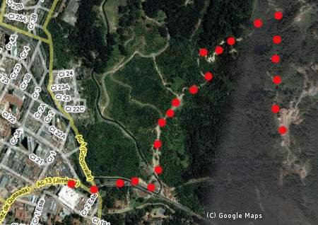
Footpath up to Cerro de Monserrate
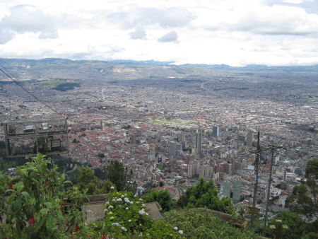
View over Bogota from Cerro de Monserrate

Parque Natural Chicaque
Parque Chicaque is private park just outside Bogota. It has over 15km of footpaths between 2,000m and 2,700m. The entrance charge for foreigners is 20,000COP.
Getting There:You can catch a normal buseta to Chicaque. First of all you need to get to Soacha (on the south western outskirts of Bogota), there are regular busetas to Soacha heading south bound of Carrera 10 (near Calle 6). Once in Soacha you can either hire a private car to take you (from Plaza de Soacha) or you can catch another bus to La Mesa and ask the driver to drop you off at the dirt road to the entrance (has a large sign for the park over the road). It is a 45 minute walk along this track to the administration building and the entrance proper. To catch the La Mesa bus walk further along the main road, there are lots of buses waiting for passengers - ask around to find the right bus.
Getting Back:If you walk back to the main road and wait there are regular busetas heading to Soacha. From Soacha you can get another Buseta to El Centro.
What's There:The park entrance is at 2,700m and you first need to follow the footpath to the bottom of the park. Here there are various paths you can follow to "La Cascada" (a big waterfall), "El Pico" (a rocky look out point) or "El Refugio" where you can buy food and rent horses.
Staying There:It is possible to stay in El Refugio or camp in the park.
Further Information: Official Park Website
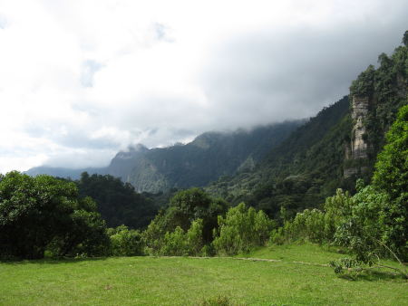
Looking Across Chicaque.

Choachi
Choachi is a small town very close to Bogota. It has a small town square with a colonial church. Close to Choachi are the thermal baths and a lagoon popular with Bogotonians. From Choachi there are good views towards the national park Chingaza.
Getting There: You can catch a bus from a terminal on Calle 6, just east of Carrera 13. Note that tourist information recommend that you do not travel to this terminal before 7am. The bus costs 6,000COP. The bus leaves Bogota through El Rocio and gives fantastic views over Bogota. The bus then travels through the mountains and drops down steeply on the other side into Choachi. The bus journey takes about 1 hour. The trip to Choachi is worth it just for the bus ride.
Getting Back:The Choachi bus terminal is on the exit from Choachi to Ubaque (in a field at the bottom of a hill near a football field). There are regular services back to the Bogota terminal on Calle 6.
What's There: From the Choachi bus terminal it is a 5 minute walk to the main square, there are various restaurants and bars on the main square. There is meant to be a market on a Sunday but it wasn't there when we visited.
There is also a natural thermal spa in the town of Santa Monica, Santa Monica is about 2km from Choachi. There are lots of buses waiting in Choachi (near the main square) which go straight to the thermals.
Alternatively you can walk to Laguna Sagrada de Ubaque. This is on the road towards Ubaque; you can either walk towards Ubaque from Choachi or you could ask one of the buses to Ubaque to drop you off. The lagoon is about 6km from Choachi (2km on tarmac and then 4km up hill on dirt tracks). The dirt tracks turn off the Choachi - Ubaque road on the right just before a stream and are marked by a small cross. Before you get to the turn off you go past a house with a huge concrete barrier in front (to stop cars from hitting the house) and a massive wooden cross.
To get to the lagoon follow the dirt tracks up the mountain side, take each turn off marked with a wooden cross. It takes about 2 hours to walk up the mountain side. The countryside is very pretty with good views over Chingaza and lots of bird life.
Further Information: Santa Monica Spa Website, Choachi Government Website
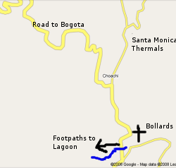
Map of the area around Choachi.
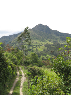
Area around Laguna Sagrada de Ubaque.

Suesca
Suesca is a small town north of Bogota which is a very popular day destination. It is also the main rock climbing area for Bogotonians. At Suesca there is rocking climbing, hiking and white water rafting.
Getting There:Catch the Transmilenio to the northern terminal, from there you can get a buseta to Suesca (4,800COP). The journey takes about 1 hour.
Getting Back:There are regular buses returning to the Transmilenio northern terminal.
Rock Climbing:There is a big cliff that is a couple of kilometres long and 150m high in places. As you arrive in Suesca there is a set of restaurants along the side of the road, get off here. There is a sign post to "rocas de suesca", follow this to the railway track, turn left and follow the railway track for 4 minutes to get to the crag. Near the sign post is a climbing shop called Mono Dedo where you can hire a guide or book climbing classes.
Hiking:There are meant to be a lot of hiking trails in the area but it seems to be very hard to find out about them. One 2 hour walk we did was to follow the railway tracks under the climbing areas. Walk along the tracks for about 50 minutes until the crag on your right drops down to your level, you can then double back on yourself and follow a footpath back along the top of the crags to Suesca. From the top of the crag you can see on to the surrounding hills and the sandy hiking trails stand out clearly allowing you to plan other walks.
Staying There:There are these two hostels Hotel La Esperanza, Posada de la Montana or you can camp. There is a camp site at the bottom of the crag.
Further Information:Mono Dedo climbing store
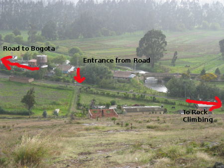
Locations in Suesca
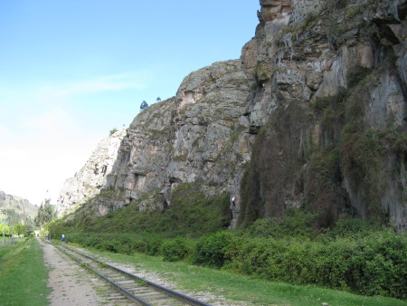
Rock climbing in Suesca.

Laguna de Guatavita
Laguna de Guatavita is a small lagoon in a volcano crater just north of Bogota. The lagoon is a national park and run by CAR. The lagoon is a famous Musica sacred site where gold offerings were made. It is equally famous for the failed attempts of Spaniards to drain the lake while searching for gold. The crater now has a large V cut into the side of it from these failed attempts.
The lake is a 7km hike up paved and dirt roads from where the bus drops you off. You no longer have to pre-organise a permit to visit the park. The entrance fee for tourists is 12,000COP and you have to join a guided tour of the lake.
The tour takes about 1.5 hours and involves a slow plod up to the rim of the crater. Those wanting a longer walk can carry on alone around the crater once the tour party leaves via the exit. The tour is linear, setting off from the ticket office and exiting the park at a separate gate (you can not return directly to the ticket office), there is a path and bus that returns tours back to the car park. For those who have walked up, the return walk to the bus is only 5km from the exit gate.
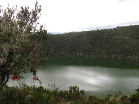
Looking down on the Laguna
Getting There:Catch the Transmilenio to the northern terminal, from there you can get a buseta to Guatavita (6,000COP). Ask the bus driver to drop you off at the correct location. There is a blue sign on the Sesquile - Guatavita road pointing to the national park. From here you follow paved roads to the top of the hill, all of the turn offs are clearly sign posted. From the top of the hill the road gains a yellow line and drops into some zig zags. The paved road finally finishes and you have about 1.5km left on a dirt road. The return route joins this road opposite the first bar on the dirt track (do not be tempted to try and enter the park this way, the gate is guarded). Follow the signs on the dirt track to reach the entrance gate.
Returning:From the exit gate follow the track down hill. You will reach some huts selling food and beer. Follow the road, passing the huts on your left. At the cross roads go straight on and up a little hill, there is a large hill in front of you. The road bends round to the right and heads down hill avoiding the large hill. Stay on this track until you reach the main road again opposite the pre-mentioned bar. Walk back the way you came up. Catch a bus back to Bogota from the blue sign.
Time: The above itinerary took us 4.5 hours in total, including the tour.
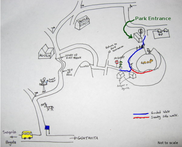
Map of how to walk to Laguna de Guatavita.
What's there: Lots of paths around the top of the crater with well preserved wildlife and excellent views over the surrounding mountains. The paths reach 3,100m according to the sign at the ticket office.
Further Information:Official CAR website for Laguna de Guatavita
return to top, download google earth file or return to travel guide to colombia.
Embalse de El Neusa
Neusa Reservoir blocks the source of Rio Bogota. It is a park run by CAR and is very close to Bogota (1.5 hours by bus). At the reservoir you can camp, hire boats or just go for a walk.
Getting There:Buses go from Bogota Terminal and are run by Carmen (Cundinamarca might also run services). According to the CAR website there are direct buses at 9.30am and 11.30am, however when we arrived at 9.20am on a Sunday we were told there was not a 9.30am bus. Alternatively, there are regular bus services from Zipaquira to the park or you can get a bus to Ubate and ask the driver to drop you off at the Neusa turn off (between Zipaquira and Ubate) and wait for a local bus there. Note that some buses only go to Rio Neusa which is another park run by CAR, however it is very small and only for picnics and barbeques. From the turn off on the Zipaquira/Ubate road it is 14km to Embalse de Neusa, from Rio Neusa park it is a 7km walk up hill (and very straight forward). The walk from Rio Neusa is very pleasent with fantastic views back accross the valley to Bogota.
Getting Back:The last direct bus from the park entrance to Bogota is at 3.30pm, however there may be later buses running to Zipaquira.
Costs: The bus journey costs about 6,000COP per person. Entrance to the park is 3,500COP.
Map of Embalse de Neusa with facilities shown.
Looking accross the reservoir from the dam.
Further Information:Official CAR website for Embalse de Neusa
return to top, download google earth file or return to travel guide to colombia.
Sopò and Parque Pionono
Sopò is just a 30 minute bus journey from the Northern Portal of the transmilenio. From Sopò you can do the 2 hour walk to Parque Pionono which overlooks Sopò. The park has typical paramo vegetation including frailijones, the views from the top of the park are amazing.
Getting There:Buses leave from the Northern Terminal of the transmilenio and take about 30 minutes. The journey costs 3,100COP per person. Buses will drop you off at the terminal in Sopò.
Getting Back:Regular buses leave from the terminal at Sopò.
Getting to the park: Walk back towards the centre of the town from the bus terminal. You need to follow Calle 4 towards the mountain, this will bring you to Santuario del Señor de la Piedra. Turn left in front of the Santuario and then immediately right to follow the wall of the Santuario up a very steep hill. Keep following this road straight on and eventually you will pick up signs for the Park. You will pass a place for parapenting near the top of the hill. As you get near the entrance you will be able to look back behind you to see Guatavita and Embalse Tomine. The park is free to enter and you can hire guides in the park or just wander on your own. It´s worth walking to the cross that you can see on the way up, it might be possible to return to Sopò from here (but we didn´t try it). The usual way to return is the way you came.
The park is 60 hectures and mostly above 3,200metres. There are various footpaths in the park and you are free to explore.
Along the road to the park you pass signs to Guatavita, so it would be possible to do a very pleasent walk between Sopò and Guatavita.
Looking towards Guatavita
Looking up to parque Pionono, the cross is on the far right hill.
Video from Youtube with guides showing you around the Parque Pionono.
Further Information:Wikipedia page for Sopò.
return to top, download google earth file or return to travel guide to colombia.
Cerro de Majuy (Majuy Hill)
Majuy Hill is just above Cota (near Chia and to the west of Bogota) and can be seen from all over Bogota. The countryside is safer here than the hills to the East of Bogota. The round walk from Chia to the top and back takes between 3 and 4 hours. Majuy Hill is just under 3100 high.
There are two ways to get to Cota, either via the Transmilenio Portal Norte or from the Transmilenio Portal 80. From Portal Norte catch a bus to Chia (1800COP) and then from Chia catch a bus to Cota (1200COP). From Portal 80 you can catch a bus directly to Cota (1800COP).
In Cota get off at the main square, on the main road. The map below shows the route to Majuy Hill (Cerro de Majuy). You cross through the town of Cota to a hotel on the side of the hill and follow a gravel road along the bottom of the hill. The gravel road ends at a cross road, take the right hand turn up the valley through lots of small farm holdings.
The road eventually ends and there is a paved footpath on the right heading up to the ridge. Once at the ridge you can go either left or right.
Go right to reach Majuy Hill, this path steeply follows a blunt ridge. On the top of the hill is a small house and radio mast (take some stones for an aggressive dog).
Go left to reach an alternative hill that is slightly lower than Majuy but has no radio masts on the summit.
Map of route from Cota to Majuy Hill (Cerro de Majuy).
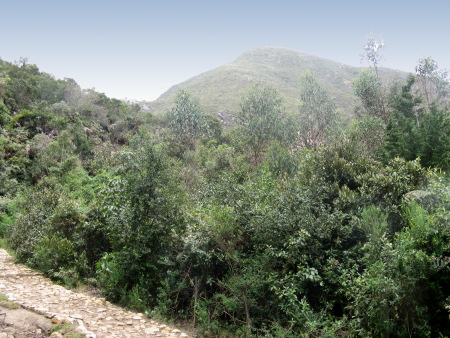
The summit of Majuy from the footpath.

Parque Ecologico Matarredonda / Parque Ecologico de Verjon
Matarredonda/Verjon Park is in the hills above Bogota, however it is far enough away to be safe. It only takes 30 minutes to reach the park from central Bogota and has very beautiful paramo making it an ideal day trip from Bogota. The park is between 3,300 and 3,600 metres above sea level.
The park is halfway between Bogota and Choachi, you get their using the Choachi bus from the terminal on Calle 6 near Carrera 13 (see section above on Choachi for further information). Our bus driver did not know where the park was, however if you sit on the right hand side of the bus and look out for the entrance you cannot miss it. The park is about 5 minutes after the first pass that the road crosses.
From the park you can visit some nice lakes and visit some waterfalls (that we failed to find). The man at the entrance said that we shouldn't go past the lagoons but we did and the footpath is very easy to follow. If you follow it for long enough you end up near the hill with TV masts (that can be seen from Monserrate). The hill could be easily ascended. From the park entrance to the hill takes under 2 hours.
We were charged 7000COP each to enter the park, although we're not sure if the gate always has someone present.
To get onto the main path, walk through the park gate and up a short hill. There is a house and road on the left (which apparently leads to the waterfalls), on the right is a barbed wire fence and a short cobbled path. The cobbled path is the childrens' educational path, you want to take the dirt track that slowly rises just to the left of the childrens' educational path.

The entrance to Parque de Matarredonda/Verjon.
The lagunas in Parque de Matarredonda/Verjon.
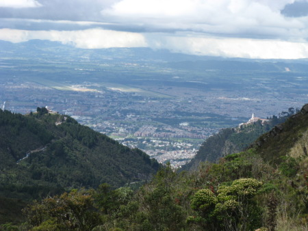
The view of Bogota and Monserrate from the base of the hill with the TV masts.
The paramo in Parque de Matarredonda/Verjon.

Chingaza National Park - Lagunas de Siecha
Lagunas de Siecha are just 1.5 hours from Bogota but the scenery is spectacular. The walk we did took 6 hours and formed a circuit including a hill above the lagunas with great views. There are other paths within the area allowing you to have an easier or harder walk.
Chingaza National Park covers a huge area but most of the park is extremely hard to access. Lagunas de Siecha are one of the exceptions. Most of the water for Bogota comes from Chingaza and so the authorities are quite protective of the park. In theory you should seek permission before entering the park.
To access the park from Bogota; catch the Transmilenio to Calle 72. There are some buses on the corner of Calle 72 and Carrera 13 that go to Guasca via La Calera. Catch one of these buses to Guasca (4,200COP, 1 hour). From Guasca you need to catch a bus from Guasca bus terminal to Pasohonda (2000COP, 30 minutes). This bus will drop you off close enough to the park to walk up to the lagunas. The bus to Pasohonda leaves Guasca at about 9.30am and takes half an hour. To return there is a bus at 5pm from Pasohonda. There might be other buses during the day.
Ignore all signs to "Lago de Siecha", this is a different place for sport fishing.
|
|
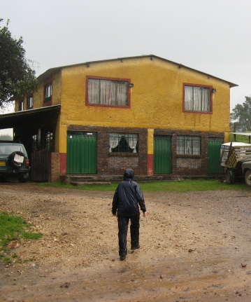
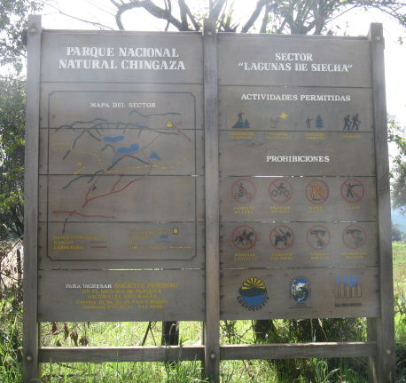
Start of our Walk to Lagunas de Siecha.
Our walk started at the above sign (the house will be on your left). This sign is at a fork in the road. The bus will go to the right - this is an easier walk to the lagunas. We took the left hand fork which takes you up to Loma del Chochal which has fantastic views over the lagunas.
Follow this track for about 1 hour. At the first fork in the track both tracks meet up again shortly (the left hand track is steep and eroded - the right hand track is smoother for cars). Shortly afterwards there is another track heading down hill on your left - ignore this. At the next fork the good road continues to the left and an overgrown track leads to the right. Take the righthand track - after 50 metres this becomes a very pleasent footpath that takes you up to the paramo.
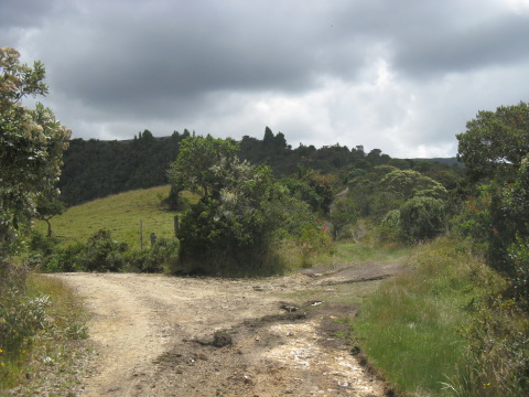
Take the right hand track which becomes a footpath.
Keep following this footpath, eventually the ridge above the lagunas will come into view. You can see a footpath in the bottom of the valley on your left (this is probably reached by following the good track - see above). Eventually the footpath comes out onto a broad ridge. Follow this ridge with increasingly spectacular views to reach Loma de Chochal. 3 hours from sign to summit.
Once on Loma de Chochal there is a path leading down to the lagunas. From the lagunas there is a good path leading left and right. After looking at the lagunas and optionally walking up the the high laguna, head right on the footpath towards the furthest of the lagunas (which can be seen from the top of Loma de Chocal). This footpath will take you back down past the warden's hut.
From the warden's hut there is a track, follow this track back down to the sign. From summit to sign is 3 hours. From the sign you can catch a bus back to Guasca.
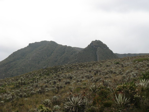
The ridge above the lagunas coming into view.
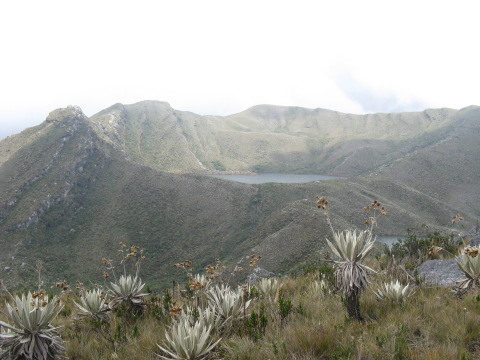
The high laguna and the one below is just visible.
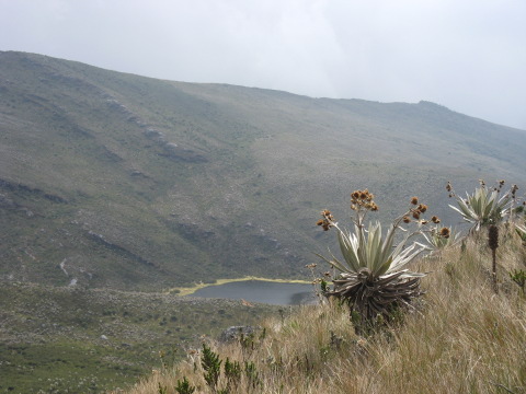
The third laguna that you should pass on the way down to the warden's hut.
Further Information:
- Diarios Del Caminante Page dealing with how to access Lagunas de Siecha (spanish).
- Walking Guide Another guide detailing how to walk to Lagunas de Siecha (spanish).
- National Parks A page from the National Parks website covering access to Lagunas de Siecha.
- National Parks Page The page on this site dealing with National Parks - includes more general links on Chingaza.
- Walking in Chingaza Blog Entry Another expat's walking experience in Chingaza.

Piedras Del Tunjo
Piedras Del Tunjo is a park run by CAR. It is not very big but famous for the rock paintings that can be seen there. Piedras Del Tunjo park is only 10 minutes walk from the centre of Facatativa.
Two hours is more than enough to look around the park. A lot of the rock paintings have been badly damaged by vandalism, however there is currently an effort to try and restore some of the better rock art.
Facatativa is one hour from Bogota and it is a very busy bus route. Most buses to Facatativa go from Puenta Aranda which can be reached by buseta in Bogota (loads of busetas go there from Calle 19 and Carrera 3). Alternatively you could get a bus from Soacha.
In Facatativa walk to the main plaza and follow calle 6 or 7, keep going straight on and eventually you will reach the park.
The rocks that make up the park.
Some rock art.
Map of Park.
Further Information:
- Wikipedia Wikipedia page on the rocks and rock art.

Other Trips
Here is a list of other places and parks close to Bogota that we plan to visit but haven't yet:
- Parque Embalse de El Sisga A large reservoir near to Bogota also managed by car. (CAR Webpage on park).
- Parque Juan Pablo II A small park near the border Cundinamarca and Boyaca run by CAR (CAR Webpage on park).
- Parque Embalse de el Hato Another reservoir in Cundinamarca run by CAR (CAR Webpage on park).
- Salto del Tequendama A huge waterfall on the River Bogota near Soacha.

Further Information
- Nacional Parks Website: information in the national parks, including Chingaza and Sumapaz which are close to Bogota.
- CAR Website: information on Parque Embalse de El Sisga, Parque Embalse de el Nuesa, Parque Embalse de el Hato, Parque Arqueologico Piedas del Tunjo and Parque Juan Pablo II.
- Cundinamarcamia Website: List of "Ecotourism" ideas.
- Lakes Run A trail that is run (once a year) between various important Muisca lagunas in Cundinamarca.
- National Cultural Information Information on tourist sites in Cundinamarca.
- Bogota Bus Terminal Website: Check the departure times for buses and see which companies run which services.
- Transmilenio Website: Check routes and running times for reaching the various portals.
- Bird Watchers Website information on where to bird watch safely near to Bogota - however also includes tips on safe places to walk and how to get to areas.
- My Google Earth Links File contains all of the above locations as pins in Google Earth. You need to have Google Earth installed for this to work. Google Earth can be downloaded from here.
- Google Maps Links The above Google Earth file in Google Maps.
- Marshes and Wetlands There a number of wetlands within Bogota which have a number of endemic birds and possibly an endemic guinea pig (apparently there is some debate as to whether their just feral guinea pigs).
- What do Do in and Around Bogota A few ideas from another traveller for places to visit around Bogota.
- A List of Walks Only includes start and end, you'll have to do the rest.
- The Swiss Hostel Some walks near the Swiss Hostel (near Choachi).
- Walking Routes a few walking routes near Bogota in Spanish. Includes route information.
- Walking Ideas A list of walks in Cundinamarca in Spanish. Includes route information.
- Bogota A page on this website with information on Bogota.
Hiking Clubs: Most hiking in Colombia is done is large groups within a club. Here are some links to some of the Bogota based clubs:
return to top, download google earth file or return to travel guide to colombia.© James Richardson 2008, Contact, Home, Back to Colombia Travel Guide