Sogamoso

Introduction
Sogamoso is in Boyaca and has a population of 90,000. It is about 4 hours North of Bogota. Sogamoso is at 2,600metres above sea level and surrounded by the Andes.
Close to Sogamoso is Lake Tota, the sea of Boyaca. You can also go walking in the Pàramo and reach nearly 4,000metres above sea level.
Getting There:Buses leave Bogota terminal regularly and tickets cost about 22,000COP per person. The main companies are Libertadores and Concorde. Sogamoso is on the Northern route to Yopal.
Where to Stay:
We stayed at Hotel Bachuè on Carrera 10, #13-68. A double room costs 60,000COP per night. The hotel was slightly run down but clean. The receptionist was incredibly helpful and very friendly. Phone (8) 7702512. Email:
There is also the Hotel Real at Carrera 10, #13-11. The rooms where 120,000COP per night for a double room. The phone number is (8) 7701378
Things to do: From Sogamoso you can easily reach Lake Tota. You can also visit the village of Mongui which is very traditional but not as overly touristy as places like Villa de Leyva and Barichara. The main attraction in Sogamoso is the Temple del Sol, the largest Muisca museum in Colombia.
Maps: The Google Earth imagery for this area is very poor, however this file contains the locations of the villages mentioned on this page and can be downloaded here. You can also see this map in Google Maps.
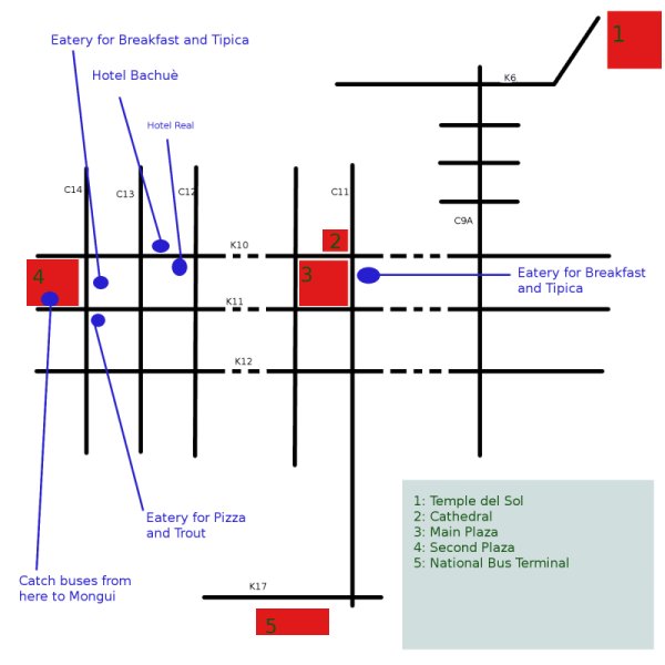
This map covers the locations mentioned on this page within Sogamoso:

Sogamoso Map
Places in Sogamoso:
There are two main plazas in Sogamoso, both between carreras 10 and 11. The main plaza with the cathedral is near calle 11 and the second plaza is near calle 14. Both plazas have a selection of eateries and cafes around them.
The main national bus terminal on carrera 17 between calles 11 and 11A. You can catch buses here to Mongui and Aquitania.
The main shopping street is Carrera 11 between the two plazas. Carrera 12 has a large number of chicken and pizza restuarants.
Sun Temple and Muisca Museum
The largest Muisca Museum in Bogota is based in Sogamoso. There is a lot of Musica pottery and tools. The impressive Musica gold work is all in the Gold Museum in Bogota. There is also a reconstruction of the sun temple (the original was burnt down by the Spanish). The address of the Museum is Calle 9A No 6-45.
Further Information:
- Hostel Trail The Hostel Trail Guide to Sogamoso.

Aquitania and Lake Tota
Lake Tota is often refered to as the sea of Boyaca. The major village on the lake is Aquitania, the village isn't on the lake but there are plenty of walking opportunities near by. While we visited the onion harvest was occuring and the whole place smelt of onions. The only buses serving the lake seem to go to Aquitania (buses leave the terminal in Sogamoso).
There is a beach on lake Tota which is further around the lake from Aquitania.
For a short walk for great views over the lake: When facing the cathedral in the main square in Aquitania, walk out of the town to the right (on the same road that the cathedral is on). As you leave the town the road turns up hill to the right, there is a small footpath on the left. The footpath goes up hill following a row of white crosses, eventually you reach a small temple and cave with a viewing platform. The walk takes about 30 minutes from the centre of Aquitania to the viewing platform.
There are plenty of tracks leaving Aquitania and heading into the hills surrounding the valley (the viewing platform will give you plenty of ideas).

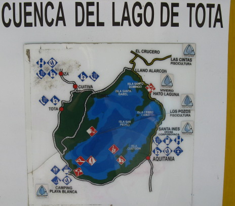
Lake Tota Map
White Crosses Along Footpath to Viewing Platform
Lake Tota

Monqui and Paramo de Oceta
Monqui is a lovely small colonial village 30 minutes from Sogamoso and unlike some of the colonial villages in Cundinamarca and Boyaca it is not overrun by tourists.
The Paramo de Oceta is a remote paramo above the village of Monqui. There is a famous canyon in the Paramo called Ciudad de Piedras which has many different coloured mosses and lots of frailejones. There is an excellent walk from Monqui to the top of a mountain at 3,900 metres in the middle of the paramo.
Ciudad de Piedras
Buses from Sogamoso drop you off in the main square of Mongui. Walk up the road on the right hand side of the cathedral (this was the largest relgious building in Colombia when it was built in the 1700 hundreds). The road is steep, follow this and some small paths to reach the mobile phone mast above the village. The track leads up the hill and is in good condition for most of the route.
At a white cross go left, you then cross a small bridge. After the small bridge you can either go up a sandy path on the right as a shortcut or follow the road. When you reach the next branch in the track - there is a rough track going right and the good track going left. The branch on the left leads to a logging area. Take the right hand track and continue up the hill (there is a large rocky hill on the left - it should stay there).
The track continues up through small farm holdings. Eventually you cross to the right hand side of the valley and cross a small stream. The path zig zags around to gain height, you then pass through a cutting. The footpath to the paramo is on the right - it is not obvious. If you continue a long the track (and miss the turning) - the track will shortly run out, cross a field and become a footpath rising up the back of the valley - turn back. See the photos below to help you recognise the correct footpath.
The correct footpath follows a stream bed and then goes along the bottom of a field. The footpath goes around the bottom of a ridge. You will reach a fork in the footpath, you need to double back on yourself to the right and cross another stream. The footpath follows the bottom of a ridge (the ridge is on your left). Part of the path is now shut off by a barbed wire fence. You can either climb over the fence and follow the path or follow the detour along the top.
Finally you reach a crossroad between two footpaths. On the right hand corner is a field with a barbed wire fence all the way around it. Turn left and follow the barbed wire fence. The path will zig-zag up the ridge. When you reach the top follow the ridge to the right. Eventually you will drop down slightly below the mountain.
You are now at the foot of the paramo, work you way on footpaths towards the far left summit. You should reach two stone columns, these are the entrance to the canyon. Climb down into the canyon and explore.
Walk through the canyon, the footpath will eventually start going up hill again. Keep on it and eventually you will reach the summit.
Either return the same way, or once dropping off the summit follow the ridge to another barbed wire fence. You can see the ridge from here and drop down through the paramo to the ridge without returning back through the canyon.
A round trip from Monqui to the summit and back took us 8 hours. You can hire guides in Mongui.
Walking Map to Reach Paramo de Oceta
Turnoff from track to Paramo - do not miss it
The mountain you are walking up. Taken from the top of ridge I (on the map). You should approach the mountain from the right of this photo.
Entrance to the canyon.
© James Richardson 2008, Contact, Home, Back to Colombia Travel Guide